
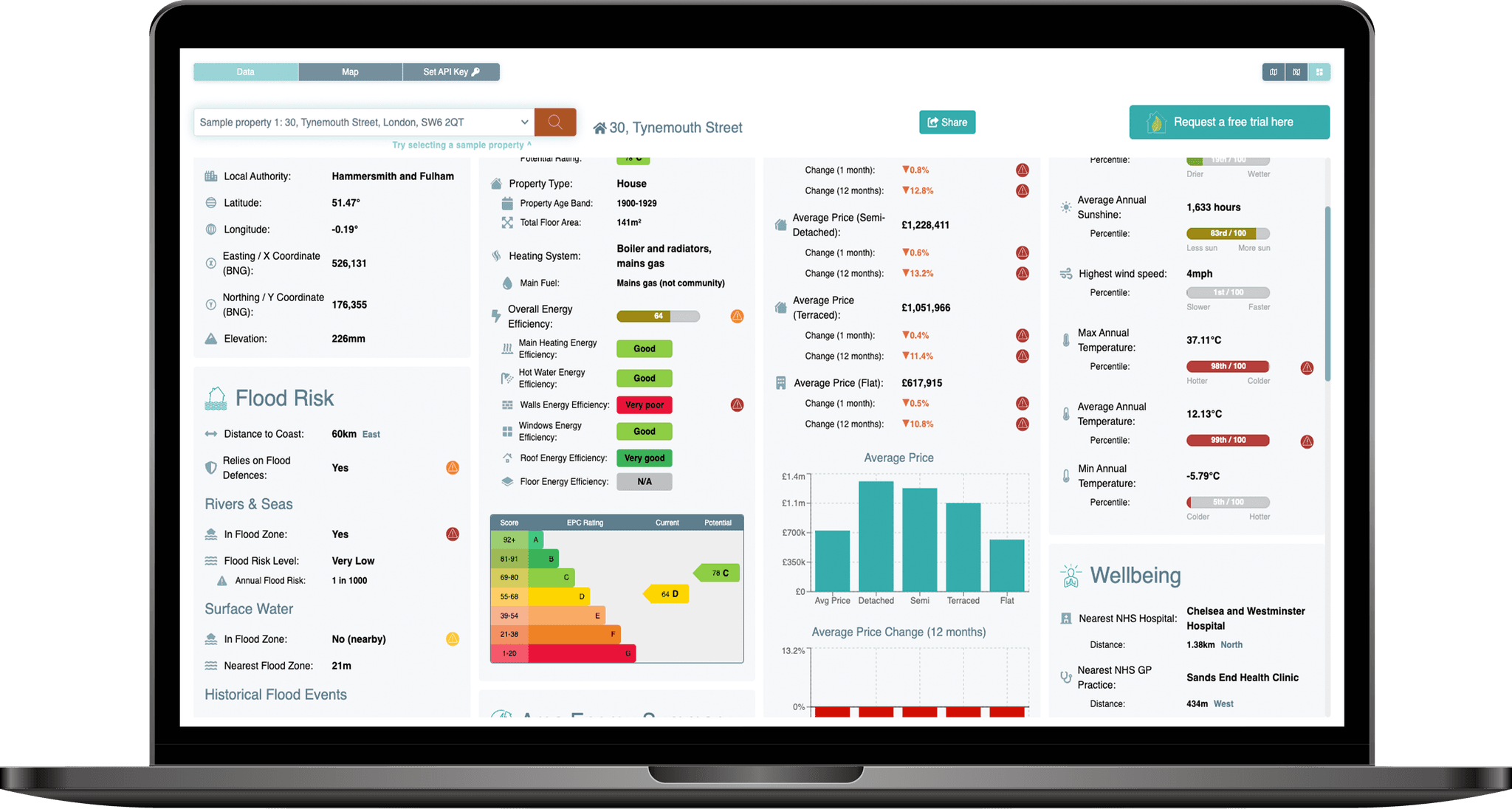
The PropEco Property Data API provides property-specific data & analysis relating to a wide range of social & environmental features including:
 Environmental risks
Including flooding (from rivers and seas), coastal erosion, radon exposure and landslides.
 Energy efficiency
Including EPC data, retrofit grants, planning restrictions and related statistics.
 Climate
Historical trends and future projections covering rainfall, temperature, sunshine and wind.
 Area attributes
Including air quality, house price trends, fuel poverty rates and average energy consumption.
 Access to amenities
Including greenspace, hospitals, GP practices, EV chargepoints and defibrillators.
 Location details
Details of the administrative boundaries within which the property sits.
{
	"uprn": 34076006,
	"location": {
		"uprn": 34076006,
		"x_coord": 526131,
		"y_coord": 176355,
		"latitude": 51.47211,
		"longitude": -0.1853445,
		"admin_boundaries": {
			"postcode": "SW6 2QT ",
			"census_output_area_code": "E00009707",
			"county_code": "E13000001",
			"county_electoral_division_code": "E99999999",
			"local_authority_district_code": "E09000013",
			"electoral_area_code": "E05013747",
			"health_area_code": "",
			"country_code": "E92000001",
			"region_code": "E12000007",
			"parliamentary_constituency_code": "E14001160",
			"european_electoral_region_code": "E15000007",
			"travel_to_work_area_code": "E30000234",
			"itl_area_code": "E09000013",
			"national_park_code": "E65000001",
			"census_lower_layer_super_output_area_code": "E01035487",
			"census_middle_layer_super_output_area_code": "E02000394",
			"census_workplace_zone": "E33033988",
			"ccg_lhb_chp_area_code": "E38000256",
			"built_up_area_code": "E63004944",
			"census_rural_urban_classification": "",
			"census_output_area_classification": "",
			"local_enterprise_partnership_code": "E37000051",
			"local_enterprise_partnership_secondary_code": "",
			"police_force_area_code": "E23000001",
			"electoral_area_name": "Sands End",
			"local_authority_district_name": "Hammersmith and Fulham",
			"county_name": "Inner London",
			"region_name": "London",
			"country_name": "England"
		},
		"elevation": {
			"elevation_upper": 3.38,
			"elevation_lower": -1.74,
			"elevation_estimate": 0.22616070943282707,
			"distance_from_upper": 264.82580663159666,
			"distance_from_lower": 424.7964218305467,
			"azimuth_ascending_degrees": 109.46256560940512,
			"azimuth_descending_degrees": 56.639128942775336,
			"is_above_high_tide_line": false
		}
	},
	"planning": {
		"conservation_areas": {
			"in_conservation_area": true,
			"conservation_area": 2273851.360423345,
			"conservation_area_proportion": 0.7284610971871447,
			"nearest_conservation_area": {
				"name": "No data available for publication by HE",
				"distance": 0,
				"nearest_point": null
			}
		},
		"listed_buildings": {
			"nearest_listed_buildings": [
				{
					"distance": 272.41512439657237,
					"x_coord": 525868,
					"y_coord": 176426,
					"latitude": 51.472806531397,
					"longitude": -0.1891041684463748,
					"name": "LANGFORD SCHOOL INCLUDING WALL, RAILINGS, GATES AND ENTRANCES, AND FORMER SCHOOL KEEPER'S HOUSE AND SPECIAL SCHOOL",
					"grade": "II",
					"date_listed": "2009-08-07T00:00:00.000Z",
					"url": "https://historicengland.org.uk/listing/the-list/list-entry/1393408"
				},
				{
					"distance": 404.0792001575929,
					"x_coord": 526507,
					"y_coord": 176503,
					"latitude": 51.47335618299173,
					"longitude": -0.17988103993397028,
					"name": "CREMORNE BRIDGE, WEST LONDON EXTENSION RAILWAY BRIDGE",
					"grade": "II*",
					"date_listed": "2008-11-26T00:00:00.000Z",
					"url": "https://historicengland.org.uk/listing/the-list/list-entry/1393006"
				},
				{
					"distance": 458.9226514348578,
					"x_coord": 526004,
					"y_coord": 176796,
					"latitude": 51.47610153134201,
					"longitude": -0.18701529184615112,
					"name": "FORMER LABORATORY AT THE IMPERIAL GAS WORKS",
					"grade": "II",
					"date_listed": "2007-06-07T00:00:00.000Z",
					"url": "https://historicengland.org.uk/listing/the-list/list-entry/1392024"
				},
				{
					"distance": 475.8875917693169,
					"x_coord": 526021,
					"y_coord": 176818,
					"latitude": 51.47629546512971,
					"longitude": -0.1867627986006931,
					"name": "OFFICE BUILDING AT THE FORMER IMPERIAL GAS WORKS",
					"grade": "II",
					"date_listed": "2007-06-07T00:00:00.000Z",
					"url": "https://historicengland.org.uk/listing/the-list/list-entry/1392025"
				},
				{
					"distance": 494.7100160700206,
					"x_coord": 526618,
					"y_coord": 176442,
					"latitude": 51.47278316819499,
					"longitude": -0.17830549025813644,
					"name": "CREMORNE BRIDGE, WEST LONDON EXTENSION RAILWAY BRIDGE, BATTERSEA",
					"grade": "II*",
					"date_listed": "2008-11-26T00:00:00.000Z",
					"url": "https://historicengland.org.uk/listing/the-list/list-entry/1393005"
				},
				{
					"distance": 495.880025812696,
					"x_coord": 525992,
					"y_coord": 176831,
					"latitude": 51.47641874954568,
					"longitude": -0.1871755311638593,
					"name": "WAR MEMORIAL",
					"grade": "II",
					"date_listed": "2007-06-07T00:00:00.000Z",
					"url": "https://historicengland.org.uk/listing/the-list/list-entry/1392026"
				},
				{
					"distance": 564.8964506880885,
					"x_coord": 526043,
					"y_coord": 176913,
					"latitude": 51.477144343651446,
					"longitude": -0.18641234280144775,
					"name": "Gasholder No 2, Fulham Gasworks",
					"grade": "II*",
					"date_listed": "1970-05-12T00:00:00.000Z",
					"url": "https://historicengland.org.uk/listing/the-list/list-entry/1261959"
				},
				{
					"distance": 654.1070248820142,
					"x_coord": 526747,
					"y_coord": 176575,
					"latitude": 51.47394959321587,
					"longitude": -0.17640147952629376,
					"name": "OLD BATTERSEA HOUSE",
					"grade": "II*",
					"date_listed": "1954-06-28T00:00:00.000Z",
					"url": "https://historicengland.org.uk/listing/the-list/list-entry/1065500"
				},
				{
					"distance": 693.9798267961396,
					"x_coord": 525549,
					"y_coord": 176733,
					"latitude": 51.47563638690693,
					"longitude": -0.19358588507184804,
					"name": "NOS 71 TO 77 INCLUDING IRON RAILINGS",
					"grade": "II",
					"date_listed": "1970-05-12T00:00:00.000Z",
					"url": "https://historicengland.org.uk/listing/the-list/list-entry/1192382"
				},
				{
					"distance": 702.7560031760668,
					"x_coord": 526776,
					"y_coord": 176634,
					"latitude": 51.474473338325936,
					"longitude": -0.17596300838320084,
					"name": "ST MARY'S VICARAGE (INCLUDING RAILINGS AND GATES)",
					"grade": "II",
					"date_listed": "1954-06-28T00:00:00.000Z",
					"url": "https://historicengland.org.uk/listing/the-list/list-entry/1299844"
				}
			]
		},
		"world_heritage_sites": {
			"in_world_heritage_site": false,
			"world_heritage_site_area": 0,
			"world_heritage_site_proportion": 0,
			"nearest_world_heritage_site": {
				"name": "Palace of Westminster, Westminster Abbey and St. Margaret's Church",
				"inscription_date": "1987-01-01T00:00:00.000Z",
				"notes": "Core Area",
				"url": "https://historicengland.org.uk/listing/the-list/list-entry/1000095",
				"distance": 4821.2320112402185,
				"nearest_point": {
					"x_coord": 529916.025999069,
					"y_coord": 179341.277999882,
					"latitude": 51.49809161098811,
					"longitude": -0.12978059568154365
				}
			}
		},
		"national_parks": {
			"in_national_park": false,
			"national_park_area": 0,
			"national_park_proportion": 0,
			"nearest_national_park": {
				"name": "South Downs",
				"distance": 52414.49214631459,
				"nearest_point": {
					"x_coord": 496678.7996,
					"y_coord": 132997.799000001,
					"latitude": 51.088152792361065,
					"longitude": -0.6209624707641703
				}
			}
		}
	},
	"environment": {
		"air_quality": {
			"benzene": {
				"percentile": 99.7940401092176,
				"value": 0.6817068
			},
			"no2": {
				"percentile": 99.90388538430152,
				"value": 20.37211
			},
			"nox": {
				"percentile": 99.89957003420896,
				"value": 30.03811
			},
			"pm2.5": {
				"percentile": 99.8356237470724,
				"value": 8.446545
			},
			"pm10": {
				"percentile": 96.75680552994667,
				"value": 14.2705
			},
			"so2": {
				"percentile": 98.54808084612246,
				"value": 2.842329
			}
		},
		"greenspace": {
			"greenspace_area": 240201.38626551873,
			"greenspace_proportion": 0.07695198042860449,
			"nearest_greenspace_point": {
				"distance": 84.52656544909924,
				"x_coord": 526210.559426686,
				"y_coord": 176326.45113151084,
				"latitude": 51.47183565629968,
				"longitude": -0.18421000854430936,
				"function": "Play Space",
				"name": null
			}
		},
		"landslides": [],
		"radon": {
			"radon_class": 1,
			"radon_affected_area": false,
			"radon_exceeding_action_level_min_likelihood": 0,
			"radon_exceeding_action_level_max_likelihood": 0.01
		},
		"subsidence": {
			"collapsible_deposits": {
				"class": 1,
				"legend": "Low",
				"advisory": "Areas of localised significant rating"
			},
			"compressible_ground": {
				"class": 1,
				"legend": "Low",
				"advisory": "Areas of localised significant rating."
			},
			"landslides": {
				"class": 1,
				"legend": "Low",
				"advisory": "Areas of localised significant rating."
			},
			"running_sand": {
				"class": 1,
				"legend": "Low",
				"advisory": null
			},
			"shrink_swell": {
				"class": 3,
				"legend": "Significant",
				"advisory": "Areas of localised significant rating."
			},
			"soluble_rocks": {
				"class": 1,
				"legend": "Low",
				"advisory": null
			},
			"shrink_swell_2030_medium_emissions": {
				"class": "Possible",
				"legend": "It is possible that climate change will effect clay shrink-swell susceptibility and change the likelihood of ground movement, which causes subsidence."
			},
			"shrink_swell_2030_high_emissions": {
				"class": "Probable",
				"legend": "It is probable that climate change will affect clay shrink-swell susceptibility and change the likelihood of ground movement, which causes subsidence."
			},
			"shrink_swell_2070_high_emissions": {
				"class": "Probable",
				"legend": "It is probable that climate change will affect clay shrink-swell susceptibility and change the likelihood of ground movement, which causes subsidence."
			},
			"shrink_swell_2050_medium_emissions": {
				"class": "Probable",
				"legend": "It is probable that climate change will effect clay shrink-swell susceptibility and change the likelihood of ground movement, which causes subsidence."
			},
			"shrink_swell_2080_medium_emissions": {
				"class": "Probable",
				"legend": "It is probable that climate change will effect clay shrink-swell susceptibility and change the likelihood of ground movement, which causes subsidence."
			}
		}
	},
	"transportation": {
		"nearest_airport": {
			"name": "London City Airport",
			"distance": 17145.32305869943,
			"azimuth_degrees": 82.41062108844619,
			"x_coord": 542798.2557996714,
			"y_coord": 180375.5331606007,
			"latitude": 51.50428,
			"longitude": 0.0561
		},
		"low_emission_zones": {
			"in_low_emission_zone": true,
			"low_emission_zone_area": 3121445.152257819,
			"low_emission_zone_proportion": 1,
			"nearest_low_emission_zone": {
				"name": "London_ULEZ",
				"url": "https://tfl.gov.uk/modes/driving/ultra-low-emission-zone",
				"distance": 0,
				"nearest_point": null
			}
		},
		"ev_charging_points": {
			"nearest_charging_points": [
				{
					"distance": 24.30039821221211,
					"x_coord": 526149.9207485385,
					"y_coord": 176370.27343384735,
					"latitude": 51.472243,
					"longitude": -0.185067,
					"name": "Tynemouth Street"
				},
				{
					"distance": 24.933474857828596,
					"x_coord": 526121.7213066816,
					"y_coord": 176378.1426135921,
					"latitude": 51.47232,
					"longitude": -0.18547,
					"name": "Tynmouth Street"
				},
				{
					"distance": 32.27425018969938,
					"x_coord": 526132.8208975578,
					"y_coord": 176322.78235664882,
					"latitude": 51.47182,
					"longitude": -0.18533,
					"name": "Lindrop Street"
				},
				{
					"distance": 57.53002049029233,
					"x_coord": 526074.6282859455,
					"y_coord": 176343.59510883206,
					"latitude": 51.47202,
					"longitude": -0.18616,
					"name": "Lindrop Road"
				},
				{
					"distance": 74.38638767951244,
					"x_coord": 526158.5241039438,
					"y_coord": 176424.11900597514,
					"latitude": 51.472725,
					"longitude": -0.184924,
					"name": "Elbe Street"
				},
				{
					"distance": 78.5727452136151,
					"x_coord": 526076.4215237667,
					"y_coord": 176411.5144449725,
					"latitude": 51.47263,
					"longitude": -0.18611,
					"name": "Tynmouth Street"
				},
				{
					"distance": 86.79300552321156,
					"x_coord": 526045.0100863599,
					"y_coord": 176366.6736162692,
					"latitude": 51.472234,
					"longitude": -0.186578,
					"name": "suby1100007179"
				},
				{
					"distance": 88.85030848083883,
					"x_coord": 526114.0300682702,
					"y_coord": 176267.7943636034,
					"latitude": 51.47133,
					"longitude": -0.18562,
					"name": "Glenrosa Street"
				},
				{
					"distance": 89.33838258305411,
					"x_coord": 526156.1746027804,
					"y_coord": 176269.28351075877,
					"latitude": 51.471334,
					"longitude": -0.185013,
					"name": "Townmead Road"
				},
				{
					"distance": 93.43933046138926,
					"x_coord": 526148.5119337098,
					"y_coord": 176446.79263576184,
					"latitude": 51.472931,
					"longitude": -0.18506,
					"name": "Elbe Street"
				}
			]
		}
	},
	"flood_risk": {
		"england": {
			"rivers_and_seas": {
				"in_flood_risk_zone": true,
				"annual_flood_risk": 0.001,
				"flood_risk_description": "Very low",
				"nearest_flood_risk_zone": {
					"max_annual_flood_risk": 0.001,
					"min_annual_flood_risk": null,
					"flood_risk_description": "Very low",
					"distance": 0,
					"nearest_point": null
				},
				"highest_risk_flood_zone_within_50m": {
					"max_annual_flood_risk": "0.001",
					"min_annual_flood_risk": null,
					"flood_risk_description": "Very low",
					"distance": 0,
					"nearest_point": null
				}
			}
		},
		"scotland": null,
		"wales": null
	},
	"climate": {
		"historical": {
			"average_rainfall": {
				"percentile": 7,
				"value": 643.1015536303859
			},
			"average_sunshine": {
				"percentile": 83,
				"value": 1632.6448389378938
			},
			"average_temperature": {
				"percentile": 99,
				"value": 12.125720497545668
			},
			"highest_wind_speed": {
				"percentile": 1,
				"value": 4.291276555464597
			},
			"maximum_temperature": {
				"percentile": 98,
				"value": 37.10990368445139
			},
			"minimum_temperature": {
				"percentile": 5,
				"value": -5.785413873490777
			},
			"highest_rainfall": {
				"percentile": 19,
				"value": 48.361393733333
			}
		},
		"future_projections": {
			"annual_hot_days": {
				"baseline_hot_days": 2.4,
				"upper_recent_hot_days": 8.6,
				"upper_recent_hot_days_change": 6.199999999999999,
				"upper_recent_hot_days_change_relative": 2.583333333333333,
				"lower_recent_hot_days": 4.6,
				"lower_recent_hot_days_change": 2.1999999999999997,
				"lower_recent_hot_days_change_relative": 0.9166666666666666,
				"upper_hot_days": 42.1,
				"upper_hot_days_change": 39.7,
				"upper_hot_days_change_relative": 16.541666666666668,
				"lower_hot_days": 7.6,
				"lower_hot_days_change": 5.2,
				"lower_hot_days_change_relative": 2.166666666666667
			},
			"maximum_temperature": {
				"baseline_maximum_temperature": 30.93,
				"upper_recent_maximum_temperature": 33.95,
				"upper_recent_maximum_temperature_change": 3.020000000000003,
				"upper_recent_maximum_temperature_change_relative": 0.09763983187843528,
				"lower_recent_maximum_temperature": 31.64,
				"lower_recent_maximum_temperature_change": 0.7100000000000009,
				"lower_recent_maximum_temperature_change_relative": 0.02295505981247982,
				"upper_maximum_temperature": 39.08,
				"upper_maximum_temperature_change": 8.15,
				"upper_maximum_temperature_change_relative": 0.2634982217911413,
				"lower_maximum_temperature": 31.88,
				"lower_maximum_temperature_change": 0.95,
				"lower_maximum_temperature_change_relative": 0.03071451665050113
			},
			"summer_precipitation": {
				"baseline_summer_precipitation": 1.53,
				"upper_recent_summer_precipitation": 1.67,
				"upper_recent_summer_precipitation_change": 0.1399999999999999,
				"upper_recent_summer_precipitation_change_relative": 0.09150326797385616,
				"lower_recent_summer_precipitation": 1.34,
				"lower_recent_summer_precipitation_change": -0.18999999999999995,
				"lower_recent_summer_precipitation_change_relative": -0.12418300653594767,
				"upper_summer_precipitation": 1.245267,
				"upper_summer_precipitation_change": -0.28473299999999996,
				"upper_summer_precipitation_change_relative": -0.1861,
				"lower_summer_precipitation": 1.320237,
				"lower_summer_precipitation_change": -0.20976300000000003,
				"lower_summer_precipitation_change_relative": -0.1371
			},
			"winter_precipitation": {
				"baseline_winter_precipitation": 1.65,
				"upper_recent_winter_precipitation": 1.97,
				"upper_recent_winter_precipitation_change": 0.32000000000000006,
				"upper_recent_winter_precipitation_change_relative": 0.193939393939394,
				"lower_recent_winter_precipitation": 1.64,
				"lower_recent_winter_precipitation_change": -0.010000000000000007,
				"lower_recent_winter_precipitation_change_relative": -0.006060606060606067,
				"upper_winter_precipitation": 2.080485,
				"upper_winter_precipitation_change": 0.4304849999999999,
				"upper_winter_precipitation_change_relative": 0.2609,
				"lower_winter_precipitation": 1.4754299999999998,
				"lower_winter_precipitation_change": -0.17457,
				"lower_winter_precipitation_change_relative": -0.1058
			}
		}
	},
	"social": {
		"house_price_index": {
			"date": "2025-01-06T00:00:00.000Z",
			"region_name": "Hammersmith and Fulham",
			"average_price": 798302,
			"average_price_seasonally_adjusted": null,
			"house_price_index": 94.6,
			"house_price_index_seasonally_adjusted": null,
			"percentage_change_1_month": 1,
			"percentage_change_12_months": -2.9,
			"sales_volume": null,
			"average_price_detached": 1812233,
			"house_price_index_detached": 94.9,
			"percentage_change_1_month_detached": 2,
			"percentage_change_12_months_detached": -0.2,
			"average_price_semi_detached": 1570323,
			"house_price_index_semi_detached": 95.6,
			"percentage_change_1_month_semi_detached": 1.6,
			"percentage_change_12_months_semi_detached": -0.9,
			"average_price_terraced": 1193195,
			"house_price_index_terraced": 95.8,
			"percentage_change_1_month_terraced": 2.2,
			"percentage_change_12_months_terraced": -1.7,
			"average_price_flat": 623219,
			"house_price_index_flat": 94,
			"percentage_change_1_month_flat": 0.5,
			"percentage_change_12_months_flat": -3.4,
			"average_price_cash": 799541,
			"house_price_index_cash": 95,
			"percentage_change_1_month_cash": 1.1,
			"percentage_change_12_months_cash": -2.5,
			"sales_volume_cash": null,
			"average_price_mortgage": 797530,
			"house_price_index_mortgage": 94.4,
			"percentage_change_1_month_mortgage": 0.9,
			"percentage_change_12_months_mortgage": -3.1,
			"sales_volume_mortgage": null,
			"average_price_first_time_buyer": 684281,
			"house_price_index_first_time_buyer": 94.1,
			"percentage_change_1_month_first_time_buyer": 0.6,
			"percentage_change_12_months_first_time_buyer": -3.2,
			"average_price_former_owner_occupier": 974182,
			"house_price_index_former_owner_occupier": 95.3,
			"percentage_change_1_month_former_owner_occupier": 1.6,
			"percentage_change_12_months_former_owner_occupier": -2.3,
			"average_price_new": null,
			"house_price_index_new": null,
			"percentage_change_1_month_new": null,
			"percentage_change_12_months_new": null,
			"sales_volume_new": null,
			"average_price_existing": null,
			"house_price_index_existing": null,
			"percentage_change_1_month_existing": null,
			"percentage_change_12_months_existing": null,
			"sales_volume_existing": null
		},
		"fuel_poverty": {
			"lower_layer_super_output_area": {
				"lower_layer_super_output_area_code": "E01035487",
				"lower_layer_super_output_area_name": "Hammersmith and Fulham 023H",
				"household_count": 797,
				"fuel_poor_household_count": 63,
				"fuel_poor_household_percentage": 7.9
			},
			"local_authority": {
				"local_authority_district_code": "E09000013",
				"local_authority_district_name": "Hammersmith and Fulham",
				"household_count": 87606,
				"fuel_poor_household_count": 8937,
				"fuel_poor_household_percentage": 10.201356071501952
			},
			"region": {
				"region_code": "E12000007",
				"region_name": "London",
				"household_count": 3683167,
				"fuel_poor_household_count": 383768,
				"fuel_poor_household_percentage": 10.419511252137086
			}
		},
		"nhs_locations": {
			"nearest_hospital": {
				"distance": 1381.4277835795324,
				"azimuth_degrees": 9.34578984550776,
				"x_coord": 526355.3334399035,
				"y_coord": 177718.09105674806,
				"latitude": 51.48431015014648,
				"longitude": -0.18162970244884705,
				"name": "Chelsea and Westminster Hospital",
				"url": "http://www.chelwest.nhs.uk",
				"address1": "369 Fulham Road",
				"address2": null,
				"address3": null,
				"postcode": "SW10 9NH"
			},
			"nearest_dentist": {
				"distance": 681.5908793609101,
				"azimuth_degrees": 313.10157105812374,
				"x_coord": 525633.340821908,
				"y_coord": 176820.72681830527,
				"latitude": 51.4764060974121,
				"longitude": -0.19234094023704487,
				"name": "New Kings Rd Dental Practice",
				"url": "http://www.newkingsroaddental.com/",
				"address1": "59 New Kings Road",
				"address2": "London",
				"address3": "London",
				"postcode": "SW6 4SE"
			},
			"nearest_gp_practice": {
				"distance": 434.06832576596327,
				"azimuth_degrees": 283.72539769194384,
				"x_coord": 525709.3269117592,
				"y_coord": 176457.9908640936,
				"latitude": 51.47312927246094,
				"longitude": -0.19137622416019587,
				"name": "Sands End Health Clinic",
				"address1": "1 BROUGHTON ROAD APPROACH",
				"address2": null,
				"address3": null,
				"postcode": "SW6 2FE"
			}
		},
		"defibrillators": [
			{
				"distance": 235.07416912822993,
				"azimuth_degrees": 61.08598126721924,
				"x_coord": 526303.1706507438,
				"y_coord": 176515.05352858896,
				"latitude": 51.47351,
				"longitude": -0.18281,
				"location_name": "St George West London",
				"availability": "Varied Access",
				"access_type": "Restricted"
			},
			{
				"distance": 245.9736845902014,
				"azimuth_degrees": 71.2084966660904,
				"x_coord": 526344.0110737708,
				"y_coord": 176478.00136569107,
				"latitude": 51.4731679,
				"longitude": -0.1822355,
				"location_name": "Tesco Express",
				"availability": "Varied Access",
				"access_type": "Public"
			},
			{
				"distance": 245.9736845902014,
				"azimuth_degrees": 71.2084966660904,
				"x_coord": 526344.0110737708,
				"y_coord": 176478.00136569107,
				"latitude": 51.4731679,
				"longitude": -0.1822355,
				"location_name": null,
				"availability": "24/7 Access",
				"access_type": "Public"
			},
			{
				"distance": 247.73214370873944,
				"azimuth_degrees": 70.68290278093768,
				"x_coord": 526343.9572473392,
				"y_coord": 176481.57182084583,
				"latitude": 51.4732,
				"longitude": -0.182235,
				"location_name": "Tesco Express",
				"availability": "Varied Access",
				"access_type": "Public"
			},
			{
				"distance": 296.9739246713631,
				"azimuth_degrees": 162.66725601637975,
				"x_coord": 526195.0154642942,
				"y_coord": 176065.00770309207,
				"latitude": 51.4694895,
				"longitude": -0.1845269,
				"location_name": null,
				"availability": "Varied Access",
				"access_type": "Restricted"
			},
			{
				"distance": 360.7357203229259,
				"azimuth_degrees": 332.1803354451811,
				"x_coord": 526009.6531294279,
				"y_coord": 176694.7134040912,
				"latitude": 51.47519,
				"longitude": -0.18697,
				"location_name": null,
				"availability": "Varied Access",
				"access_type": "Restricted"
			},
			{
				"distance": 412.61979435184134,
				"azimuth_degrees": 277.85397144271155,
				"x_coord": 525726.0143506106,
				"y_coord": 176434.00454720808,
				"latitude": 51.47291,
				"longitude": -0.1911446,
				"location_name": "Howdens At Fulham",
				"availability": "Varied Access",
				"access_type": "Restricted"
			},
			{
				"distance": 418.2963525450163,
				"azimuth_degrees": 358.7007552458446,
				"x_coord": 526114.7233277552,
				"y_coord": 176772.9795551137,
				"latitude": 51.47587,
				"longitude": -0.18543,
				"location_name": "St George West London",
				"availability": "24/7 Access",
				"access_type": "Public"
			},
			{
				"distance": 432.54243697514346,
				"azimuth_degrees": 279.33733272619804,
				"x_coord": 525710.1172957504,
				"y_coord": 176454.75324078917,
				"latitude": 51.4731,
				"longitude": -0.191366,
				"location_name": null,
				"availability": "Varied Access",
				"access_type": "Public"
			}
		],
		"indices_of_deprivation": {}
	},
	"energy": {
		"average_energy_usage_stats": {
			"middle_layer_super_output_area": {
				"middle_layer_super_output_area_code": "E02000394",
				"electricity_meter_count": 6391,
				"mean_electricity_usage": 3897.7722,
				"mean_electricity_cost": 1190.3972870599998,
				"median_electricity_usage": 2698.5,
				"median_electricity_cost": 881.8245499999999,
				"gas_meter_count": 2368,
				"mean_gas_usage": 10279.344,
				"mean_gas_cost": 759.5254751999998,
				"median_gas_usage": 8285.126,
				"median_gas_cost": 633.2914758
			},
			"lower_layer_super_output_area": {
				"lower_layer_super_output_area_code": "E01035487",
				"electricity_meter_count": 904,
				"mean_electricity_usage": 2726.0457,
				"mean_electricity_cost": 888.9120586099999,
				"median_electricity_usage": 2115.6,
				"median_electricity_cost": 731.8443799999999,
				"gas_meter_count": 611,
				"mean_gas_usage": 9158.9795,
				"mean_gas_cost": 688.6064023499998,
				"median_gas_usage": 7356.4526,
				"median_gas_cost": 574.50644958
			}
		},
		"retrofit_grants": [
			{
				"name": "Boiler Upgrade Scheme",
				"description": "Grant of up to £7,500 to cover part of the cost of replacing fossil fuel heating systems with a heat pump or biomass boiler.",
				"grant_value": 7500,
				"url": "https://www.gov.uk/apply-boiler-upgrade-scheme"
			}
		],
		"epcs": {
			"epc_country": "England",
			"epc_in_date": true,
			"epc_age": 234365305850,
			"epc_expiry": "2028-04-13T00:00:00.000Z",
			"epc": {
				"address": "30, Tynemouth Street",
				"address1": "30, Tynemouth Street",
				"address2": null,
				"address3": null,
				"adjusted_costs": {
					"heating_cost_current": 1221.7,
					"heating_cost_potential": 952.7,
					"hot_water_cost_current": 208.1,
					"hot_water_cost_potential": 127.8,
					"lighting_cost_current": 132.1,
					"lighting_cost_potential": 132.1,
					"total_fuel_cost_current": 1561.9,
					"total_fuel_cost_potential": 1212.6,
					"standing_charges": 345
				},
				"building_reference_number": "8373247578",
				"built_form": "Mid-Terrace",
				"co2_emissions_current": 4.9,
				"co2_emissions_per_floor_area_m2_current": 35,
				"co2_emissions_potential": 2.7,
				"co2_emissions_reduction_potential": 2.2,
				"constituency": "E14000629",
				"constituency_label": "Chelsea and Fulham",
				"construction_age_band": "1900-1929",
				"county": "Greater London Authority",
				"dwelling_type": "New dwellings (including conversions and change of use)",
				"energy_consumption_per_floor_area_m2_current": 197,
				"energy_consumption_per_floor_area_m2_potential": 107,
				"energy_efficiency_current": 64,
				"energy_efficiency_potential": 78,
				"energy_rating_current": "D",
				"energy_rating_potential": "C",
				"energy_tariff": "Single",
				"environmental_impact_current": 55,
				"environmental_impact_potential": 72,
				"extension_count": 1,
				"fixed_lighting_outlet_count": null,
				"flat_storey_count": null,
				"floor_description": "Suspended, no insulation (assumed)",
				"floor_energy_efficiency": null,
				"floor_environmental_efficiency": "N/A",
				"floor_height": null,
				"floor_level": null,
				"floor_thermal_transmittance": null,
				"floor_type": "suspended",
				"glazed_area": "Normal",
				"glazed_type": "Double",
				"habitable_room_count": 6,
				"has_mains_gas": true,
				"has_solar_water_heating": false,
				"heat_loss_corridor": null,
				"heat_pump": false,
				"heated_room_count": 6,
				"heating_cost_current": 822,
				"heating_cost_potential": 641,
				"hot_water_cost_current": 140,
				"hot_water_cost_potential": 86,
				"hot_water_description": "From main system",
				"hot_water_energy_efficiency": "Good",
				"hot_water_environmental_efficiency": "Good",
				"inspection_date": "2018-04-13T00:00:00.000Z",
				"is_flat_top_storey": null,
				"lighting_cost_current": 85,
				"lighting_cost_potential": 85,
				"lighting_description": "Low energy lighting in 96% of fixed outlets",
				"lighting_energy_efficiency": "Very Good",
				"lighting_environmental_efficiency": "Very Good",
				"lmk_key": "1623275129962018041317050037478788",
				"local_authority": "E09000013",
				"local_authority_label": "Hammersmith and Fulham",
				"lodgement_date": "2018-04-13T00:00:00.000Z",
				"lodgement_datetime": "2018-04-13T17:05:00.000Z",
				"low_energy_fixed_light_count": null,
				"low_energy_lighting_percentage": 96,
				"main_fuel": "Mains gas (not community)",
				"main_heating_controls": "2106",
				"main_heating_controls_description": "Programmer, room thermostat and TRVs",
				"main_heating_controls_energy_efficiency": "Good",
				"main_heating_controls_environmental_efficiency": "Good",
				"main_heating_description": "Boiler and radiators, mains gas",
				"main_heating_energy_efficiency": "Good",
				"main_heating_environmental_efficiency": "Good",
				"mechanical_ventilation": "Natural",
				"multi_glaze_percentage": 100,
				"open_fireplace_count": 2,
				"post_town": "London",
				"postcode": "SW6 2QT",
				"property_type": "House",
				"report_type": "Standard Assessment Procedure (SAP)",
				"roof_description": "Pitched, 300 mm loft insulation",
				"roof_energy_efficiency": "Very Good",
				"roof_environmental_efficiency": "Very Good",
				"roof_photovoltaic_supply": null,
				"roof_thermal_transmittance": null,
				"roof_type": "pitched",
				"second_heating_description": "Room heaters, mains gas",
				"tenure": "Owner-Occupied",
				"total_energy_consumption_current": 27777,
				"total_energy_consumption_potential": 15087,
				"total_floor_area": 141,
				"transaction_type": "Marketed Sale",
				"unheated_corridor_length": null,
				"uprn": 34076006,
				"uprn_source": "Address Matched",
				"walls_description": "Solid brick, as built, no insulation (assumed)",
				"walls_energy_efficiency": "Very Poor",
				"walls_environmental_efficiency": "Very Poor",
				"walls_thermal_transmittance": null,
				"walls_type": "solid",
				"wind_turbine_count": 0,
				"windows_description": "Fully Double Glazed",
				"windows_energy_efficiency": "Good",
				"windows_environmental_efficiency": "Good"
			}
		}
	}
}
Pricing
Subscription plans are designed to be accessible and flexible.
Exploration
£29/mo
- Property-level assessments
- Access to all API endpoints
- Up to 250 calls per month*
Start-up
£69/mo
- Property-level assessments
- Access to all API endpoints
- Up to 750 calls per month*
Scale-up
£149/mo
- Property-level assessments
- Access to all API endpoints
- Up to 3,000 calls per month*
Enterprise
£POA/mo
- Property-level assessments
- Access to all API endpoints
- Dedicated & customised endpoint
*Usage is based on a credit system in which the number of credits consumed per API call varies by endpoint. Figures shown are for level one endpoints such as Property Data, EPCs or Flood Risk.
Contact us for information on enterprise-level pricing.
All API subscriptions can be used to assess properties and locations using the PropEco Data Explorer and any API endpoint.

Need more information? Submit any questions or requests via the form below.
You can also contact us at info@propeco.io or connect with us on LinkedIn here.