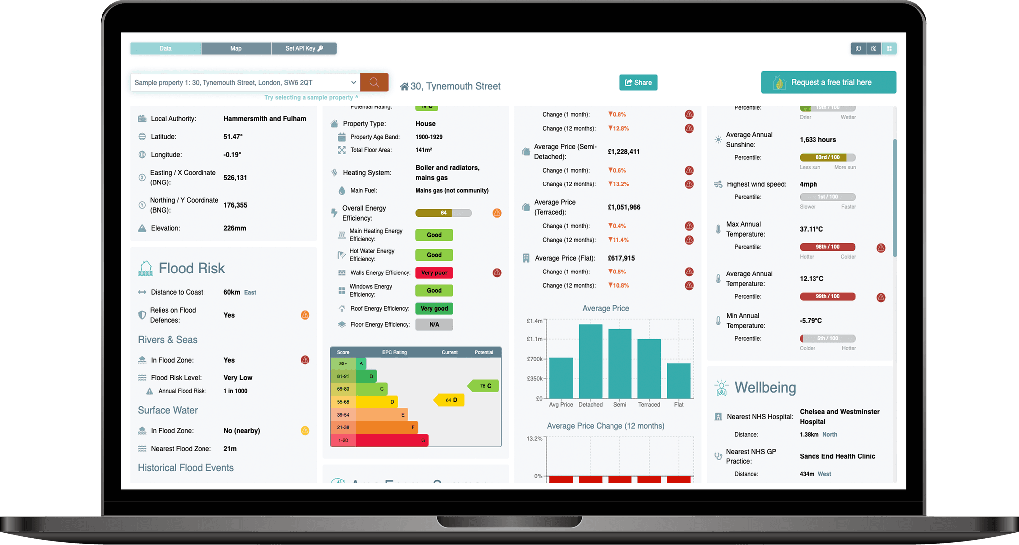
The PropEco Retrofit API provides property-specific data & analysis to inform and streamline property retrofit, including:
 Enahnced EPCs
Cleaned and augmented EPC data.
 EPC Estimate
Estimated assessments for properties without an EPC.
 EPC Stats
Statistical analysis of the energy efficiency of the wider housing stock.
 EPC Compare
Energy efficiency and carbon footprint benchmarking.
 Planning restrictions
Including detailed assessments of nearby conservation areas and listed buildings.
 Area attributes
Including house price trends, fuel poverty rates and average energy consumption.
 Location details
Details of the administrative boundaries within which the property sits.
{
	"uprn": 10034632229,
	"location": {
		"x_coord": 202301,
		"y_coord": 47402,
		"latitude": 50.2933563,
		"longitude": -4.7770112,
		"admin_boundaries": {
			"postcode": "PL26 6BJ",
			"census_output_area_code": "E00096200",
			"county_code": "E99999999",
			"county_electoral_division_code": "E99999999",
			"local_authority_district_code": "E06000052",
			"electoral_area_code": "E05013846",
			"health_area_code": "",
			"country_code": "E92000001",
			"region_code": "E12000009",
			"parliamentary_constituency_code": "E14000961",
			"european_electoral_region_code": "E15000009",
			"travel_to_work_area_code": "E30000270",
			"itl_area_code": "E06000052",
			"national_park_code": "E65000001",
			"census_lower_layer_super_output_area_code": "E01019040",
			"census_middle_layer_super_output_area_code": "E02003964",
			"census_workplace_zone": "E33048767",
			"ccg_lhb_chp_area_code": "E38000089",
			"built_up_area_code": "",
			"census_rural_urban_classification": "",
			"census_output_area_classification": "",
			"local_enterprise_partnership_code": "E37000005",
			"local_enterprise_partnership_secondary_code": "",
			"police_force_area_code": "E23000035",
			"electoral_area_name": "Mevagissey & St Austell Bay",
			"local_authority_district_name": "Cornwall",
			"county_name": null,
			"region_name": "South West",
			"country_name": "England"
		},
		"elevation": {
			"elevation_upper": 60,
			"elevation_lower": 50,
			"elevation_estimate": 55.87437430964115,
			"distance_from_upper": 61.95136452347257,
			"distance_from_lower": 43.50899816025484,
			"azimuth_ascending_degrees": 325.4691742577052,
			"azimuth_descending_degrees": 107.9279197618614,
			"is_above_high_tide_line": true
		}
	},
	"planning": {
		"conservation_areas": {
			"in_conservation_area": false,
			"conservation_area": 287431.266837996,
			"conservation_area_proportion": 0.09208275424287644,
			"nearest_conservation_area": {
				"name": "Pentewan",
				"distance": 123.86578521797773,
				"nearest_point": {
					"x_coord": 202177.4748,
					"y_coord": 47392.8208000008,
					"latitude": 50.29323243499839,
					"longitude": -4.778738684281515
				}
			}
		},
		"listed_buildings": {
			"nearest_listed_buildings": [
				{
					"distance": 291.54190435100406,
					"x_coord": 202012.6536,
					"y_coord": 47445.0469000004,
					"latitude": 50.293646271303544,
					"longitude": -4.78107720712394,
					"name": "32-36, NORTH ROAD",
					"grade": "II",
					"date_listed": "1974-03-11T00:00:00.000Z",
					"url": "https://historicengland.org.uk/listing/the-list/list-entry/1211737"
				},
				{
					"distance": 294.47511810074644,
					"x_coord": 202006.6693,
					"y_coord": 47392.7785999998,
					"latitude": 50.293174749888294,
					"longitude": -4.781133731522965,
					"name": "14-22, NORTH ROAD",
					"grade": "II",
					"date_listed": "1974-03-11T00:00:00.000Z",
					"url": "https://historicengland.org.uk/listing/the-list/list-entry/1211655"
				},
				{
					"distance": 296.81471648414623,
					"x_coord": 202036.5693,
					"y_coord": 47267.1839000005,
					"latitude": 50.292056599496256,
					"longitude": -4.780648667555122,
					"name": "WELL HOUSE AND PUMP AT REAR OF NUMBER 5 CHURCH ROW",
					"grade": "II",
					"date_listed": "1999-11-08T00:00:00.000Z",
					"url": "https://historicengland.org.uk/listing/the-list/list-entry/1379471"
				},
				{
					"distance": 303.5061778613411,
					"x_coord": 202001,
					"y_coord": 47356,
					"latitude": 50.292842474188916,
					"longitude": -4.78119395481263,
					"name": "4 AND 6, NORTH ROAD",
					"grade": "II",
					"date_listed": "1974-03-11T00:00:00.000Z",
					"url": "https://historicengland.org.uk/listing/the-list/list-entry/1289909"
				},
				{
					"distance": 308.7736600643705,
					"x_coord": 202027.6693,
					"y_coord": 47258.3632999994,
					"latitude": 50.29197437955045,
					"longitude": -4.780768840732125,
					"name": "CHURCH ROW",
					"grade": "II",
					"date_listed": "1950-11-28T00:00:00.000Z",
					"url": "https://historicengland.org.uk/listing/the-list/list-entry/1211656"
				},
				{
					"distance": 322.94519059668687,
					"x_coord": 202026.5195,
					"y_coord": 47231.8410999998,
					"latitude": 50.29173575159748,
					"longitude": -4.780771067467888,
					"name": "CHURCH OF ALL SAINTS",
					"grade": "II",
					"date_listed": "1950-11-28T00:00:00.000Z",
					"url": "https://historicengland.org.uk/listing/the-list/list-entry/1211746"
				},
				{
					"distance": 422.6770451582589,
					"x_coord": 201915.6794,
					"y_coord": 47228.2647999991,
					"latitude": 50.29166641856263,
					"longitude": -4.782323364371144,
					"name": "HARBOUR QUAYS",
					"grade": "II",
					"date_listed": "1974-03-11T00:00:00.000Z",
					"url": "https://historicengland.org.uk/listing/the-list/list-entry/1211649"
				},
				{
					"distance": 570.087712549569,
					"x_coord": 201751,
					"y_coord": 47252,
					"latitude": 50.2918243055833,
					"longitude": -4.784644903051749,
					"name": "BRIDGE OVER ST AUSTELL RIVER",
					"grade": "II",
					"date_listed": "1974-03-11T00:00:00.000Z",
					"url": "https://historicengland.org.uk/listing/the-list/list-entry/1289906"
				},
				{
					"distance": 640.3332190553328,
					"x_coord": 201684.0156,
					"y_coord": 47230.6614999995,
					"latitude": 50.2916101144896,
					"longitude": -4.785572946091474,
					"name": "PUMP HOUSE WEST SOUTH WEST OF BRIDGE",
					"grade": "II",
					"date_listed": "1999-11-16T00:00:00.000Z",
					"url": "https://historicengland.org.uk/listing/the-list/list-entry/1379816"
				},
				{
					"distance": 686.842048800159,
					"x_coord": 201615,
					"y_coord": 47368,
					"latitude": 50.29282058126248,
					"longitude": -4.786612769690046,
					"name": "ROCK COTTAGE",
					"grade": "II",
					"date_listed": "1974-03-11T00:00:00.000Z",
					"url": "https://historicengland.org.uk/listing/the-list/list-entry/1289874"
				}
			]
		},
		"world_heritage_sites": {
			"in_world_heritage_site": false,
			"world_heritage_site_area": 0,
			"world_heritage_site_proportion": 0,
			"nearest_world_heritage_site": {
				"name": "Cornwall and West Devon Mining Landscape",
				"inscription_date": "2006-01-01T00:00:00.000Z",
				"notes": "Core Area",
				"url": "https://historicengland.org.uk/listing/the-list/list-entry/1000105",
				"distance": 189218.04309810488,
				"nearest_point": {
					"x_coord": 137784.557,
					"y_coord": 36064.8389999997,
					"latitude": 50.16647098640673,
					"longitude": -5.6732360994864965
				}
			}
		},
		"national_parks": {
			"in_national_park": false,
			"national_park_area": 0,
			"national_park_proportion": 0,
			"nearest_national_park": {
				"name": "Dartmoor",
				"distance": 50085.46181689296,
				"nearest_point": {
					"x_coord": 247165.1033,
					"y_coord": 69667.7971000001,
					"latitude": 50.506794836151414,
					"longitude": -4.156729498089907
				}
			}
		}
	},
	"environment": {
		"greenspace": {
			"greenspace_area": 0,
			"greenspace_proportion": 0,
			"nearest_greenspace_point": {
				"distance": 1902.810743426689,
				"x_coord": 201389.58,
				"y_coord": 45731.67,
				"latitude": 50.27804608227398,
				"longitude": -4.7889138682126715
			}
		},
		"landslides": [
			{
				"distance": 890.2415402574742,
				"x_coord": 202984,
				"y_coord": 47973,
				"latitude": 50.29871401930097,
				"longitude": -4.767731876691879,
				"name": "Polgwyn Beach"
			}
		],
		"air_quality": {
			"benzene": {
				"percentile": 54,
				"value": 0.1711982
			},
			"no2": {
				"percentile": 50,
				"value": 3.37575
			},
			"nox": {
				"percentile": 50,
				"value": 4.167889
			},
			"pm10": {
				"percentile": 62,
				"value": 10.25954
			},
			"pm2.5": {
				"percentile": 56,
				"value": 5.347714
			},
			"so2": {
				"percentile": 44,
				"value": 0.5104846
			}
		},
		"radon": {
			"radon_class": 6,
			"radon_affected_area": true,
			"radon_exceeding_action_level_min_likelihood": 0.3,
			"radon_exceeding_action_level_max_likelihood": 1
		}
	},
	"transportation": {
		"nearest_airport": {
			"name": "Newquay Airport/Newquay Cornwall Airport",
			"distance": 23143.41602172923,
			"azimuth_degrees": 302.59481234509866,
			"x_coord": 186581.68444670385,
			"y_coord": 64387.90073239463,
			"latitude": 50.44043,
			"longitude": -5.00703
		},
		"low_emission_zones": {
			"in_low_emission_zone": false,
			"low_emission_zone_area": 0,
			"low_emission_zone_proportion": 0,
			"nearest_low_emission_zone": {
				"name": "Bristol",
				"url": "https://www.cleanairforbristol.org/#intro",
				"distance": 197966.3306360684,
				"nearest_point": {
					"x_coord": 356537.4438238461,
					"y_coord": 171505.93814091035,
					"latitude": 51.440867,
					"longitude": -2.6267148
				}
			}
		},
		"ev_charging_points": {
			"nearest_charging_points": []
		}
	},
	"flood_risk": {
		"england": {
			"rivers_and_seas": {
				"in_flood_risk_zone": false,
				"annual_flood_risk": 0,
				"flood_risk_description": null,
				"nearest_flood_risk_zone": {
					"max_annual_flood_risk": null,
					"min_annual_flood_risk": 0.033,
					"flood_risk_description": "High",
					"distance": 183.93541281117837,
					"nearest_point": {
						"x_coord": 202396.2701,
						"y_coord": 47244.6601,
						"latitude": 50.29197487399054,
						"longitude": -4.7755931990765825
					}
				}
			}
		},
		"scotland": null,
		"wales": null
	},
	"climate": {
		"historical": {
			"average_rainfall": {
				"percentile": 66,
				"value": 1263.0055349701088
			},
			"average_sunshine": {
				"percentile": 84,
				"value": 1636.3958007658357
			},
			"average_temperature": {
				"percentile": 97,
				"value": 11.345667787422029
			},
			"highest_wind_speed": {
				"percentile": 85,
				"value": 10.214005310997896
			},
			"maximum_temperature": {
				"percentile": 29,
				"value": 28.73171401670606
			},
			"minimum_temperature": {
				"percentile": 2,
				"value": -5.254552600452478
			},
			"highest_rainfall": {
				"percentile": 64,
				"value": 66.82374426267212
			}
		},
		"future_projections": {
			"annual_hot_days": {
				"baseline_hot_days": 0,
				"upper_recent_hot_days": 0.8,
				"upper_recent_hot_days_change": 0.8,
				"upper_recent_hot_days_change_relative": null,
				"lower_recent_hot_days": 0.1,
				"lower_recent_hot_days_change": 0.1,
				"lower_recent_hot_days_change_relative": null,
				"upper_hot_days": 11.61904762,
				"upper_hot_days_change": 11.61904762,
				"upper_hot_days_change_relative": null,
				"lower_hot_days": 0.238095238,
				"lower_hot_days_change": 0.238095238,
				"lower_hot_days_change_relative": null
			},
			"maximum_temperature": {
				"baseline_maximum_temperature": 25.541023,
				"upper_recent_maximum_temperature": 28.31792,
				"upper_recent_maximum_temperature_change": 2.7768970000000017,
				"upper_recent_maximum_temperature_change_relative": 0.10872301395288676,
				"lower_recent_maximum_temperature": 26.61919,
				"lower_recent_maximum_temperature_change": 1.0781670000000005,
				"lower_recent_maximum_temperature_change_relative": 0.042213148627601976,
				"upper_maximum_temperature": 34.436914,
				"upper_maximum_temperature_change": 8.895891,
				"upper_maximum_temperature_change_relative": 0.3482981476505464,
				"lower_maximum_temperature": 26.8902681,
				"lower_maximum_temperature_change": 1.3492451,
				"lower_maximum_temperature_change_relative": 0.052826588034473015
			},
			"summer_precipitation": {
				"baseline_summer_precipitation": 2.158203,
				"upper_recent_summer_precipitation": 2.2985172,
				"upper_recent_summer_precipitation_change": 0.14031420000000017,
				"upper_recent_summer_precipitation_change_relative": 0.0650143661184792,
				"lower_recent_summer_precipitation": 1.8390509,
				"lower_recent_summer_precipitation_change": -0.31915209999999994,
				"lower_recent_summer_precipitation_change_relative": -0.14787862865541376,
				"upper_summer_precipitation": 1.5582646509584999,
				"upper_summer_precipitation_change": -0.5999383490415,
				"upper_summer_precipitation_change_relative": -0.2779805,
				"lower_summer_precipitation": 1.80453894343293,
				"lower_summer_precipitation_change": -0.35366405656707,
				"lower_summer_precipitation_change_relative": -0.16386969
			},
			"winter_precipitation": {
				"baseline_winter_precipitation": 3.9715192,
				"upper_recent_winter_precipitation": 4.5944457,
				"upper_recent_winter_precipitation_change": 0.6229264999999997,
				"upper_recent_winter_precipitation_change_relative": 0.15684841709943131,
				"lower_recent_winter_precipitation": 3.8682,
				"lower_recent_winter_precipitation_change": -0.10331920000000006,
				"lower_recent_winter_precipitation_change_relative": -0.026015032232501876,
				"upper_winter_precipitation": 4.98957009153768,
				"upper_winter_precipitation_change": 1.01805089153768,
				"upper_winter_precipitation_change_relative": 0.2563379,
				"lower_winter_precipitation": 3.914331487997964,
				"lower_winter_precipitation_change": -0.057187712002036005,
				"lower_winter_precipitation_change_relative": -0.014399455
			}
		}
	},
	"social": {
		"house_price_index": {
			"date": "2023-01-11T00:00:00.000Z",
			"region_name": "Cornwall",
			"average_price": 312338,
			"average_price_seasonally_adjusted": null,
			"house_price_index": 155.4,
			"house_price_index_seasonally_adjusted": null,
			"percentage_change_1_month": -0.9,
			"percentage_change_12_months": -4.1,
			"sales_volume": null,
			"average_price_detached": 462020,
			"house_price_index_detached": 160.5,
			"percentage_change_1_month_detached": -0.8,
			"percentage_change_12_months_detached": -3.8,
			"average_price_semi_detached": 305811,
			"house_price_index_semi_detached": 159.4,
			"percentage_change_1_month_semi_detached": -1,
			"percentage_change_12_months_semi_detached": -3.4,
			"average_price_terraced": 248010,
			"house_price_index_terraced": 154.2,
			"percentage_change_1_month_terraced": -1.2,
			"percentage_change_12_months_terraced": -4.6,
			"average_price_flat": 167064,
			"house_price_index_flat": 136.2,
			"percentage_change_1_month_flat": -0.2,
			"percentage_change_12_months_flat": -4.9,
			"average_price_cash": 314897,
			"house_price_index_cash": 154.5,
			"percentage_change_1_month_cash": -0.9,
			"percentage_change_12_months_cash": -4.3,
			"sales_volume_cash": null,
			"average_price_mortgage": 309661,
			"house_price_index_mortgage": 156.2,
			"percentage_change_1_month_mortgage": -0.9,
			"percentage_change_12_months_mortgage": -4,
			"sales_volume_mortgage": null,
			"average_price_first_time_buyer": 255145,
			"house_price_index_first_time_buyer": 153.4,
			"percentage_change_1_month_first_time_buyer": -0.9,
			"percentage_change_12_months_first_time_buyer": -4.3,
			"average_price_former_owner_occupier": 353247,
			"house_price_index_former_owner_occupier": 156.9,
			"percentage_change_1_month_former_owner_occupier": -0.9,
			"percentage_change_12_months_former_owner_occupier": -4.1,
			"average_price_new": null,
			"house_price_index_new": null,
			"percentage_change_1_month_new": null,
			"percentage_change_12_months_new": null,
			"sales_volume_new": null,
			"average_price_existing": null,
			"house_price_index_existing": null,
			"percentage_change_1_month_existing": null,
			"percentage_change_12_months_existing": null,
			"sales_volume_existing": null
		},
		"fuel_poverty": {
			"lower_layer_super_output_area": {
				"lower_layer_super_output_area_code": "E01019040",
				"lower_layer_super_output_area_name": "Cornwall 041C",
				"household_count": "604",
				"fuel_poor_household_count": "89",
				"fuel_poor_household_percentage": 14.735099337748345
			},
			"local_authority": {
				"local_authority_district_code": "E06000052",
				"local_authority_district_name": "Cornwall",
				"household_count": 259453,
				"fuel_poor_household_count": 36274,
				"fuel_poor_household_percentage": 13.980952234123329
			},
			"region": {
				"region_code": "E12000009",
				"region_name": "South West",
				"household_count": 2537861,
				"fuel_poor_household_count": 301799,
				"fuel_poor_household_percentage": 11.89186484208552
			}
		},
		"nhs_locations": {
			"nearest_hospital": {
				"distance": 3855.507140328097,
				"azimuth_degrees": 7.688809883895054,
				"x_coord": 202776.00404263652,
				"y_coord": 51228.13466420173,
				"latitude": 50.327884674072266,
				"longitude": -4.772349834442139,
				"name": "St Austell Community Hospital - Cornwall Partnership NHS Foundation Trust",
				"url": "http://www.cornwallft.nhs.uk/hospitals/st-austell/",
				"address1": "Porthpean Road",
				"address2": null,
				"address3": null,
				"postcode": "PL26 6AD"
			},
			"nearest_dentist": {
				"distance": 4981.479662508897,
				"azimuth_degrees": 346.6113650107945,
				"x_coord": 201735.01363578252,
				"y_coord": 52351.22206649871,
				"latitude": 50.337623596191406,
				"longitude": -4.787548065185547,
				"name": "St Austell Dental Centre (Whitecross)",
				"url": "https://www.mydentist.co.uk/saint-austell-352",
				"address1": null,
				"address2": "28 East Hill",
				"address3": null,
				"postcode": "PL25 4TR"
			},
			"nearest_gp_practice": {
				"distance": 5792.289005067789,
				"azimuth_degrees": 18.227441564573564,
				"x_coord": 203705.96491281464,
				"y_coord": 53021.31361573617,
				"latitude": 50.344303131103516,
				"longitude": -4.7602338790893555,
				"name": "St Austell Healthcare - Wheal Northey",
				"address1": "1 Wheal Northey",
				"address2": null,
				"address3": null,
				"postcode": "PL25 3EF"
			}
		},
		"defibrillators": [
			{
				"distance": 362.966500929541,
				"azimuth_degrees": 255.32740644406408,
				"x_coord": 201960.12361046992,
				"y_coord": 47277.30850928067,
				"latitude": 50.292121887207,
				"longitude": -4.78172588348389,
				"location_name": "Pentewan Village",
				"availability": "24/7 Access",
				"access_type": "Public"
			},
			{
				"distance": 872.9150125623285,
				"azimuth_degrees": 237.9799569758708,
				"x_coord": 201654.01335196503,
				"y_coord": 46816.00606110619,
				"latitude": 50.2878753,
				"longitude": -4.785776,
				"location_name": null,
				"availability": "24/7 Access",
				"access_type": "Restricted"
			}
		]
	},
	"energy": {
		"average_energy_usage_stats": {
			"middle_layer_super_output_area": {
				"middle_layer_super_output_area_code": "E02003964",
				"electricity_meter_count": 4374,
				"mean_electricity_usage": 5374.560155734617,
				"median_electricity_usage": 3782.199999999699,
				"gas_meter_count": 1026,
				"mean_gas_usage": 12157.19459636705,
				"median_gas_usage": 10583.94312451167
			},
			"lower_layer_super_output_area": {
				"lower_layer_super_output_area_code": "E01019040",
				"electricity_meter_count": 695,
				"mean_electricity_usage": 5985.417671410934,
				"median_electricity_usage": 4752.299999999953,
				"gas_meter_count": null,
				"mean_gas_usage": null,
				"median_gas_usage": null
			}
		},
		"retrofit_grants": [
			{
				"name": "Boiler Upgrade Scheme",
				"description": "Grant of up to £7,500 to cover part of the cost of replacing fossil fuel heating systems with a heat pump or biomass boiler.",
				"grant_value": 7500,
				"url": "https://www.gov.uk/apply-boiler-upgrade-scheme"
			}
		],
		"epcs": {
			"epc_country": "England",
			"epc_in_date": false,
			"epc_age": 359396450545,
			"epc_expiry": "2022-09-18T00:00:00.000Z",
			"epc": {
				"address": "Sea Barn Polrudden Farm, Pentewan",
				"address1": "Sea Barn Polrudden Farm",
				"address2": "Pentewan",
				"address3": null,
				"building_reference_number": "8643871078",
				"built_form": "Detached",
				"co2_emissions_current": 4.8,
				"co2_emissions_per_floor_area_m2_current": 41,
				"co2_emissions_potential": 2.4,
				"co2_emissions_reduction_potential": 2.4,
				"constituency": "E14000961",
				"constituency_label": "St Austell and Newquay",
				"construction_age_band": "1996-2002",
				"county": null,
				"energy_consumption_per_floor_area_m2_current": 168,
				"energy_consumption_per_floor_area_m2_potential": 69,
				"energy_efficiency_current": 66,
				"energy_efficiency_potential": 83,
				"energy_rating_current": "D",
				"energy_rating_potential": "B",
				"energy_tariff": "Single",
				"environmental_impact_current": 55,
				"environmental_impact_potential": 74,
				"extension_count": 3,
				"fixed_lighting_outlet_count": 26,
				"flat_storey_count": null,
				"floor_description": "Solid, limited insulation (assumed)",
				"floor_energy_efficiency": "N/A",
				"floor_environmental_efficiency": "N/A",
				"floor_height": null,
				"floor_level": null,
				"glazed_area": "Normal",
				"glazed_type": "Double",
				"habitable_room_count": 5,
				"has_mains_gas": false,
				"has_solar_water_heating": null,
				"heat_loss_corridor": null,
				"heated_room_count": 5,
				"heating_cost_current": 618,
				"heating_cost_potential": 555,
				"hot_water_cost_current": 176,
				"hot_water_cost_potential": 99,
				"hot_water_description": "From main system",
				"hot_water_energy_efficiency": "Average",
				"hot_water_environmental_efficiency": "Average",
				"inspection_date": "2012-09-14T00:00:00.000Z",
				"is_flat_top_storey": null,
				"lighting_cost_current": 118,
				"lighting_cost_potential": 61,
				"lighting_description": "Low energy lighting in 8% of fixed outlets",
				"lighting_energy_efficiency": "Very Poor",
				"lighting_environmental_efficiency": "Very Poor",
				"lmk_key": "836800779642012091820350708129148",
				"local_authority": "E06000052",
				"local_authority_label": "Cornwall",
				"lodgement_date": "2012-09-18T00:00:00.000Z",
				"lodgement_datetime": "2012-09-18T20:35:07.000Z",
				"low_energy_fixed_light_count": 2,
				"low_energy_lighting_percentage": 8,
				"main_fuel": "Oil (not community)",
				"main_heating_controls": "2107",
				"main_heating_controls_description": "Programmer, TRVs and bypass",
				"main_heating_controls_energy_efficiency": "Average",
				"main_heating_controls_environmental_efficiency": "Average",
				"main_heating_description": "Boiler and radiators, oil",
				"main_heating_energy_efficiency": "Good",
				"main_heating_environmental_efficiency": "Good",
				"mechanical_ventilation": "Natural",
				"multi_glaze_percentage": 100,
				"open_fireplace_count": 0,
				"post_town": "St. Austell",
				"postcode": "PL26 6BJ",
				"property_type": "House",
				"roof_description": "Pitched, insulated (assumed)",
				"roof_energy_efficiency": "Good",
				"roof_environmental_efficiency": "Good",
				"roof_photovoltaic_supply": 0,
				"second_heating_description": null,
				"tenure": "Owner-Occupied",
				"total_floor_area": 116,
				"transaction_type": "Marketed Sale",
				"unheated_corridor_length": null,
				"uprn": 10034632229,
				"uprn_source": "Address Matched",
				"walls_description": "Granite or whinstone, as built, insulated (assumed)",
				"walls_energy_efficiency": "Good",
				"walls_environmental_efficiency": "Good",
				"wind_turbine_count": 0,
				"windows_description": "Fully Double Glazed",
				"windows_energy_efficiency": "Average",
				"windows_environmental_efficiency": "Average"
			},
			"epc_estimate": null,
			"epc_stats": {
				"avg_co2_emissions_current": 5.9,
				"avg_co2_emissions_potential": 3.55,
				"avg_energy_consumption_per_floor_area_m2_current": 139.5,
				"avg_energy_consumption_per_floor_area_m2_potential": 67.5,
				"avg_energy_efficiency_current": 69.5,
				"avg_energy_efficiency_potential": 82.5,
				"avg_energy_rating_current": "D",
				"avg_energy_rating_current_numerical": 4.5,
				"avg_energy_rating_potential": "B",
				"avg_energy_rating_potential_numerical": 6,
				"energy_rating_a_count_current": 0,
				"energy_rating_a_count_potential": 0,
				"energy_rating_b_count_current": 0,
				"energy_rating_b_count_potential": 2,
				"energy_rating_c_count_current": 1,
				"energy_rating_c_count_potential": 0,
				"energy_rating_d_count_current": 1,
				"energy_rating_d_count_potential": 0,
				"energy_rating_e_count_current": 0,
				"energy_rating_e_count_potential": 0,
				"energy_rating_f_count_current": 0,
				"energy_rating_f_count_potential": 0,
				"energy_rating_g_count_current": 0,
				"energy_rating_g_count_potential": 0,
				"max_co2_emissions_current": 7,
				"max_co2_emissions_potential": 4.7,
				"max_energy_consumption_per_floor_area_m2_current": 168,
				"max_energy_consumption_per_floor_area_m2_potential": 69,
				"max_energy_efficiency_current": 73,
				"max_energy_efficiency_potential": 83,
				"max_energy_rating_current": "D",
				"max_energy_rating_potential": "B",
				"min_co2_emissions_current": 4.8,
				"min_co2_emissions_potential": 2.4,
				"min_energy_consumption_per_floor_area_m2_current": 111,
				"min_energy_consumption_per_floor_area_m2_potential": 66,
				"min_energy_efficiency_current": 66,
				"min_energy_efficiency_potential": 82,
				"min_energy_rating_current": "C",
				"min_energy_rating_potential": "B",
				"mode_energy_rating_current": "C",
				"mode_energy_rating_potential": "B",
				"perc_10_co2_emissions_current": 5.02,
				"perc_10_co2_emissions_potential": 2.63,
				"perc_10_energy_consumption_per_floor_area_m2_current": 116.7,
				"perc_10_energy_consumption_per_floor_area_m2_potential": 66.3,
				"perc_10_energy_efficiency_current": 66.7,
				"perc_10_energy_efficiency_potential": 82.1,
				"perc_10_energy_rating_current": 4.1,
				"perc_10_energy_rating_potential": 6,
				"perc_25_co2_emissions_current": 5.35,
				"perc_25_co2_emissions_potential": 2.975,
				"perc_25_energy_consumption_per_floor_area_m2_current": 125.25,
				"perc_25_energy_consumption_per_floor_area_m2_potential": 66.75,
				"perc_25_energy_efficiency_current": 67.75,
				"perc_25_energy_efficiency_potential": 82.25,
				"perc_25_energy_rating_current": 4.25,
				"perc_25_energy_rating_potential": 6,
				"perc_50_co2_emissions_current": 5.9,
				"perc_50_co2_emissions_potential": 3.55,
				"perc_50_energy_consumption_per_floor_area_m2_current": 139.5,
				"perc_50_energy_consumption_per_floor_area_m2_potential": 67.5,
				"perc_50_energy_efficiency_current": 69.5,
				"perc_50_energy_efficiency_potential": 82.5,
				"perc_50_energy_rating_current": 4.5,
				"perc_50_energy_rating_potential": 6,
				"perc_75_co2_emissions_current": 6.45,
				"perc_75_co2_emissions_potential": 4.125,
				"perc_75_energy_consumption_per_floor_area_m2_current": 153.75,
				"perc_75_energy_consumption_per_floor_area_m2_potential": 68.25,
				"perc_75_energy_efficiency_current": 71.25,
				"perc_75_energy_efficiency_potential": 82.75,
				"perc_75_energy_rating_current": 4.75,
				"perc_75_energy_rating_potential": 6,
				"perc_90_co2_emissions_current": 6.78,
				"perc_90_co2_emissions_potential": 4.470000000000001,
				"perc_90_energy_consumption_per_floor_area_m2_current": 162.3,
				"perc_90_energy_consumption_per_floor_area_m2_potential": 68.7,
				"perc_90_energy_efficiency_current": 72.3,
				"perc_90_energy_efficiency_potential": 82.9,
				"perc_90_energy_rating_current": 4.9,
				"perc_90_energy_rating_potential": 6,
				"postcode": "PL26 6BJ",
				"property_count": 2,
				"stddev_co2_emissions_current": 1.5556349186104041,
				"stddev_co2_emissions_potential": 1.6263455967290599,
				"stddev_energy_consumption_per_floor_area_m2_current": 40.30508652763321,
				"stddev_energy_consumption_per_floor_area_m2_potential": 2.1213203435596424,
				"stddev_energy_efficiency_current": 4.949747468305833,
				"stddev_energy_efficiency_potential": 0.7071067811865476,
				"stddev_energy_rating_current": 0.7071067811865476,
				"stddev_energy_rating_potential": 0
			}
		}
	}
}
Pricing
Subscription plans are designed to be accessible and flexible.
Exploration
- Property-level assessments
- Physical & transition climate risks
- Wellbeing impacts
- Up to 250 calls per month
Start-up
- Property-level assessments
- Physical & transition climate risks
- Wellbeing impacts
- Up to 750 calls per month
Scale-up
- Property-level assessments
- Physical & transition climate risks
- Wellbeing impacts
- Up to 3,000 calls per month
Contact us for information on enterprise-level pricing.
All API subscriptions can be used to assess properties and locations using the PropEco Data Explorer, Properties endpoint, Location endpoint, EPCs endpoint and flood risk endpoint.

Need more information? Submit any questions or requests via the form below.
You can also contact us at info@propeco.io or connect with us on LinkedIn here.


